
Longitude, as a geographical coordinate, identifies east-west position on Earth, with lines of longitude, or meridians, running from pole to pole. Because of the Earth’s rotation, the difference in longitude between two locations is equivalent to the difference in their local times: one degree of longitude equals a four-minute time difference, and 15 degrees is equal to one hour (making 360 degrees, or 24 hours, in total). There is no naturally occurring zero point, or prime meridian, and so it is for historical and contingent reasons that we have come to measure longitude from a meridian that runs through Greenwich, near London in the United Kingdom. Longitude was far more difficult than latitude (north-south position) to measure by astronomical observation. Latitude is defined in relation to the equator and could be calculated by observing the maximum altitudes of the Sun or other stars using instruments such as astrolabes, cross-staffs and back-staffs. Longitude, in contrast, came to be defined in the early modern period as a difficult technical problem that was either insoluble or a challenge to be met with improved mathematics, astronomy and instrumentation.
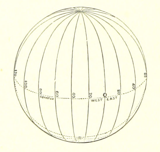
Figure 1: Diagram of the lines of longitude as printed in George Goudie Chisholm’s “The World As It is” from 1883-1884, courtesy British Library digital collections .
The problem of finding longitude was, historically, linked to maritime navigation, where a lack of visible reference points in the skies or on land made position-finding particularly difficult. While mariners had means of keeping track of their position, including by dead reckoning (where duration and direction of travel at an estimated speed is used to calculate a new position from and old one), it was impossible to calculate longitude directly. For routes that were largely known (especially coastal routes), or that could be navigated by sailing to a particular latitude and then heading directly east or west (known as latitude sailing), the inability to fix longitudinal positions accurately could be overcome. However, as trade routes and imperial ambitions expanded, monarchs, merchants and investors were increasingly interested in the possibility of improved methods of navigation that might increase the scope for expansion and reliability of profits. Western imperialism and commercial expansion underpin the history of longitude, for methods of navigation developed earlier or in other parts of the world did not rely on longitude and latitude coordinates. 1
Between the sixteenth and eighteenth centuries, the interest of states and other patrons in identifying successful longitude methods led to the foundation of institutions – such as observatories, standing committees and schools – and the establishment of monetary rewards. While theoretical solutions were known, the many scientific and technical difficulties involved in implementing them meant that many considered it impossible. The large sums involved excited public interest and raised the stakes far beyond most contemporary astronomical or calculational problems. Longitude projectors, seeking investment in schemes, tools and techniques, seen as cheats, fools or, at least, likely to drive themselves and others mad with wasted time and money. In an age of print, public prizes generated public debate and satire, with longitude placed alongside other tantalizing impossibilities like making the philosopher’s stone, turning base metals into gold, or creating a perpetual motion machine. 2
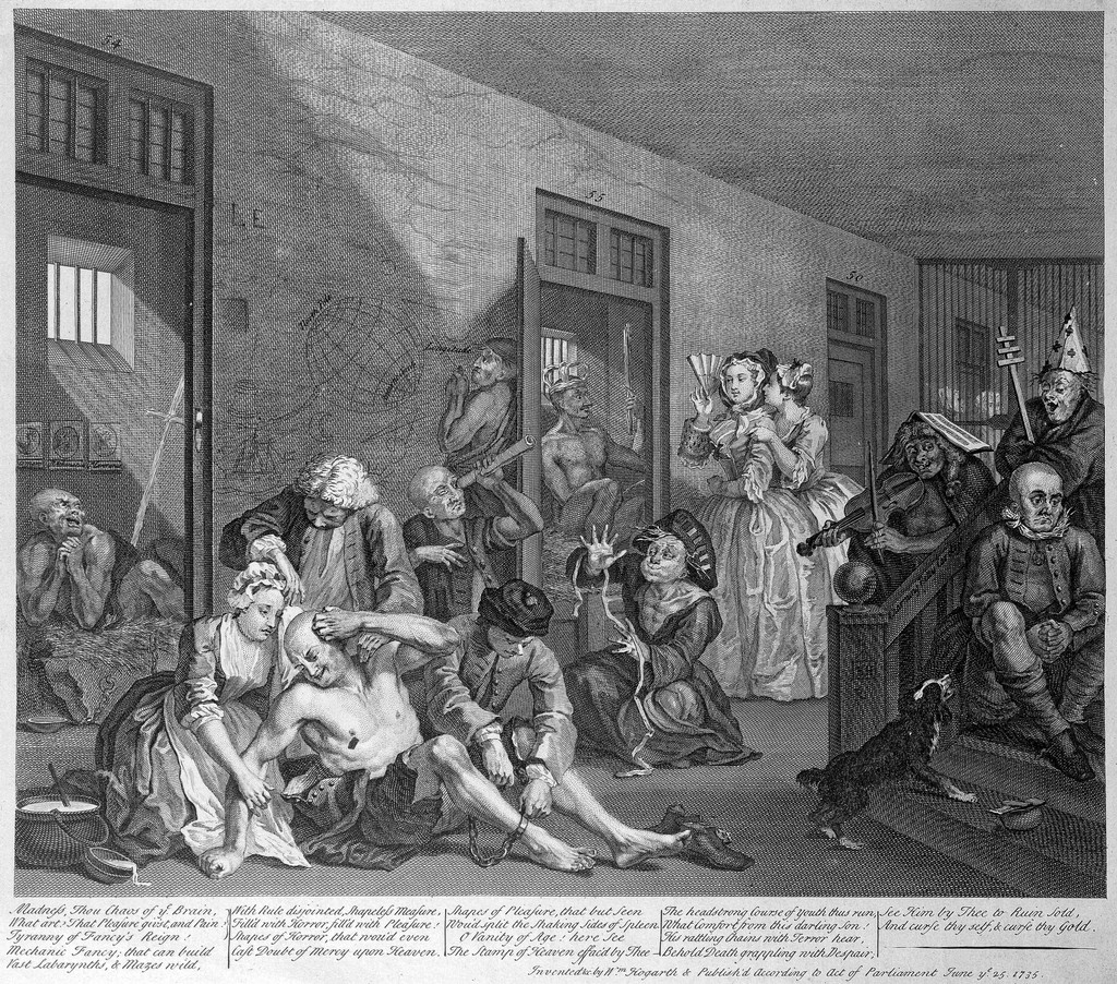
Figure 2: The “longitude lunatic” within 18 th -century satire: a figure scribbling “solutions” to the problem of longitude is visible on the back wall in the “Scene at Bedlam” from William Hogarth’s The Rake’s Progress , courtesy Wellcome Collection .
The implementation and routinization of successful methods eventually lessened public interest but, in the twentieth century, longitude regained wide recognition as a tale of singular heroic inventors, competitive rivalry, and national triumph. 3 These tropes can be difficult to overcome, despite growing scholarship emphasizing the international scope of the problem, the involvement of the ideas and labor of large numbers of people and the combined role of private and public investment. 4 Longitude is a topic that has long drawn the attention of historians of science, since it not only facilitated significant research and investment in science but also played a significant role in the public culture of science. Curators of relevant collections of scientific instruments have been responsible for much of this research, often reflecting the technical, institutional and national contexts within which they worked. Longitude remains a classic example where public fascination with science as a story of triumph—individual and national—persists, despite the sustained efforts of scholars to emphasize the importance of context, as well as of social and cultural approaches to history. 5
Early measures of longitude
In ancient Greece, scholars understood difference in longitude as difference in time. In the second century BCE, Claudius Ptolemy outlined existing methods for establishing geographical positions, particularly those of Hipparchus (c. 190–120 BCE), which included simultaneous observations of a lunar eclipse. It was known that this phenomenon would appear at the same moment anywhere it was visible on Earth but at different local times. Comparing notes after the event would allow a calculation of the time difference, and so the difference in longitude, between the two locations. This was correct in theory but difficult to put into practice. Derek Howse suggests that Ptolemy’s Geography contained only one astronomically determined difference of longitude – that between Arbela and Carthage, established with the observation of an eclipse in 330 BCE. 6
Comparing the local time of eclipse observations remained the only astronomical method of establishing differences in longitude until the sixteenth century. However, by the late fifteenth century, Christopher Columbus benefitted from having a copy of the printed astronomical ephemerides published by Regiomontanus, which predicted the positions of the Sun, Moon and planets as they would appear at Nuremburg. This gave him a reference time against which to compare observations that he made in the Caribbean in 1494 and 1503, although errors in both predictions and the observations meant that the accuracy was very poor. Such methods were, however, used to map lands of the Spanish empire in the 1570s–80s and there are examples of English navigators observing eclipses to establish longitudes in explorations of coasts of the Americas in the seventeenth century. 7
Eclipse observations were more often made to improve geographical knowledge for future navigators than to aid ongoing navigation, and were made once the ship had reached land. While there are examples of Spanish and Portuguese navigators making use of astronomy to establish longitudes in the sixteenth century, dead reckoning remained the core method of navigation. The errors known to exist in navigational tables and the difficulty of making observations at sea meant that few considered astronomical methods of finding longitude an improvement to existing methods. As Martin Fernandez de Enciso wrote in Suma de Geographia in 1519, ‘Sailors calculate distance in an East-West direction in nights and days and with an hourglass and the calculation is reasonably correct for those who know their ship well and how much it sails in a hour’. 8 Deliberate over-estimation ensured that a careful watch was kept well in advance of any approach to land.
However, at the start of the sixteenth century, the possible ways of determining longitudes by astronomy increased. Most significant was the development of the lunar-distance method, described in print by Johann Werner of Nuremburg in 1514 and in a roughly contemporary manuscript by Rui Faleiro that was evaluated during the 1519–1522 circumnavigation of Ferdinand Magellan. 9 This method involved the measurement of the angle formed between the Moon and a star, and of their altitudes, which could be compared to predictions of the position of the Moon. These measurements could be made with a cross-staff but complex calculations were required and knowledge of the Moon’s motions was insufficient to produce accurate results. Nevertheless, small numbers of mathematically adept individuals attached to voyages continued to experiment with and record lunar distances, eclipses, transits and occultations throughout the sixteenth and seventeenth centuries.
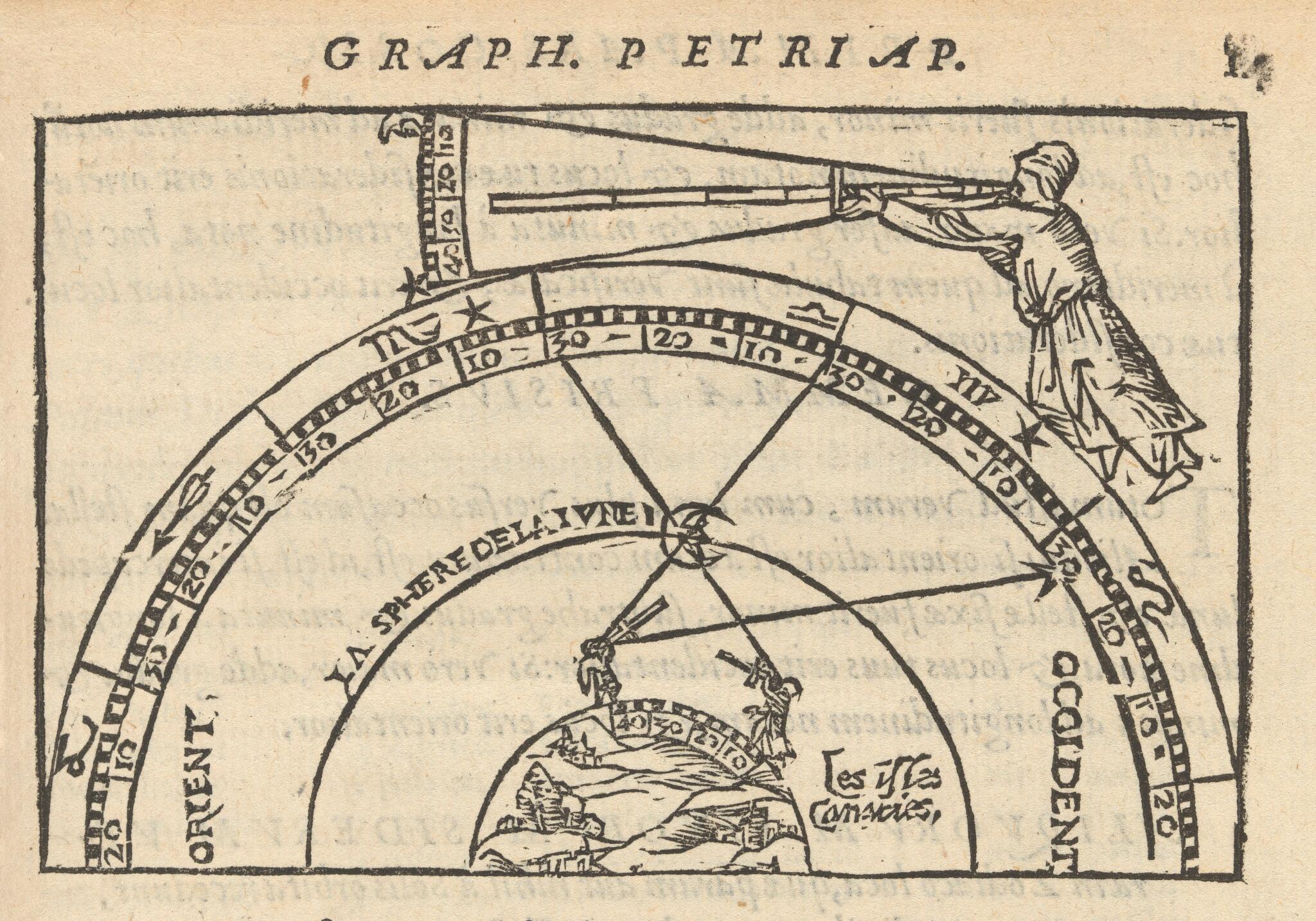
Figure 3: A 1551 depiction of the lunar-distance method (using a cross staff) from the work of Peter Apian, courtesy Wellcome Library .
While dead reckoning continued to be key, and astronomical methods chiefly circulated in mathematical literature, a third approach was theorized and explored at sea: magnetic variation, or declination. This involved the measurement of the angular difference between magnetic north, indicated by a compass needle, and true north, established astronomically. This was known to vary geographically, and so held out hope of offering a mappable network against which east-west positions could be fixed. However, the patterns of variation are complex and were ultimately shown to change over time, meaning that any such map would not only require a very large number of observations but would also have to be regularly updated. Nevertheless, in particular locations, at certain periods of time, it could be an effective means of locating a ship. In the 1570s, drawing on observations of variation, Vicente Rodrigues identified locations in which magnetic north aligned with true north. Although the hypothesized positioning of magnetic poles and global patterns were erroneous, both Portuguese and Dutch mariners could make limited use of magnetic variation as a means of finding their position. 10
Investing in longitude
As imperial competition and trade rivalries developed in the sixteenth century, there was increasing investment in solutions to the problem of longitude. Mathematical practitioners and projectors of schemes for new or improved methods often succeeded in persuading those with money and power that financial support would pay off with workable methods. Investment was also made at an institutional level in, for example, the foundation of the Casa de la Contractación in Seville in 1503, which quickly took on a role as a center for collecting information, developing charts and instruments and training navigators. In the late seventeenth century, convinced by members of their academies that improved knowledge of positional astronomy would render the lunar-distance method viable, the kings of both France and England established observatories, in Paris in 1667 and at Greenwich in 1675. Charles II also founded a Mathematical School in 1673, designed to train future naval officers in the methods that would support astronomical navigation. Money put into finding ways to fix positions against the invisible lines of longitude often resulted in visible and long-lasting scientific institutions.
Other investment came in the form of rewards or prizes, offered by states with maritime empires. These held out the possibility of receiving life-changing amounts of money. The Spanish Empire’s expansion into South America led Philip II to offer in 1567 a reward of 6000 ducats to anyone who could offer a practical and reliable solution to the problem of finding longitude at sea. In 1598, Philip III increased the attraction of the prize by adding a life annuity of 2000 ducats and up to 1000 ducats in expenses. 11 By this date the Dutch States (States General of the United Provinces of the Dutch Republic) were also looking beyond the more local trade of the North and Baltic Seas, particularly toward the East Indies, and in 1600 they announced a reward of 5000 guilders, plus an annuity of 1000 pounds. 12
It was not until 1714 that Britain followed suit, passing an act of parliament that established a series of rewards up to £20,000. In the same year, Count Jean-Baptiste Rouillé de Meslay bequeathed 125,000 livres to the Paris Academy of Sciences, the interest on which was, from 1720, dispersed as prizes to those who submitted the best responses to questions posed in astronomy and navigation. 13 While the French prize was judged by academicians, submissions to the other prizes were adjudicated by a combination of mathematical and astronomical experts and more practical navigators. For the Spanish this was done at the Casa de la Contractación, for the Dutch via ad hoc committees, who passed ideas judged theoretically sound to practicing navigators for comment. 14 The British Longitude Act established a number of Commissioners of Longitude, including the president of the Royal Society, the Astronomer Royal and professors of astronomy and geometry at the universities. Plausible ideas were passed to the maritime guild, Trinity House, for comment on practicability, or were submitted to trial at sea. 15
While historiographical attention in Anglophone literature has tended to focus on the British Board of Longitude, rewards and patronage in other countries were active and produced work of equal significance. It has also been common to focus on the large sums offered and to understand these schemes as competitive prizes, with winners and losers. However, although the big numbers certainly drew attention, it was smaller rewards and payments of costs for developing and trialing ideas that were perhaps more significant. The Dutch States did not award their highest prize to any of the almost 40 proposals submitted by 1775, but they did cover expenses for several and Jan Hendricksz Jarichs van der Ley and his heirs received 19,000 guilders in annuities between 1625 and 1655 for his improvements to dead reckoning, incorporating trigonometrical calculations. 16 Financial records of the Board of Longitude show that large numbers of people received rewards of varying sizes between 1714 and 1828, totaling £52,534. 17
Some individuals made multiple submissions, sometimes receiving several rewards, and occasionally targeting more than one scheme. Galileo Galilei submitted proposals to both the Spanish and Dutch authorities, as well as seeking rewards or payments from the Venetian state and Medici family. These proposals were based on the recent development and improvement of the telescope and his 1610 telescopic discovery of four moons orbiting Jupiter. Galileo’s observations showed that these satellites would appear and disappear as they circled the planet with a regularity that could be predicted and used as a celestial timekeeper. In 1616 he offered the Spanish crown a proposal that involved making 100 telescopes and teaching navigators, and between 1636 and 1642 he engaged in protracted negotiations with the Dutch government. 18 This method of establishing longitude became, with the publication of more accurate predictive tables by Giovanni Cassini at the Paris Observatory in 1668, an important tool for precision land survey but it remained a very difficult observation to make on board ship. Galileo and others, well into the 19th century, came up with ideas for stabilizing the observer so that it might be done but they proved unsuccessful.
The range of potential rewards have often been interpreted as single prizes, creating a competitive narrative about who might find the solution first, but in practical terms they were more relevant as a general spur to, and reflection of, interest in navigation in an age of empire. Ultimately the greatest successes were achieved when payments could be used to support the development of promising methods over the long term, rather than as one-off retrospective rewards.
Complementary methods: timekeeping and astronomy
The emphasis on competition has also led to a misunderstanding of the relationship between so-called rival methods. Indeed, the multiplicity of potential solutions was one of the driving factors in sustaining investment. When the 1714 Longitude Bill was discussed in the British parliament, Sir Isaac Newton, president of the Royal Society, outlined the possible approaches then recognized. 19 The methods he sketched included one proposed by the lobbyists behind the bill, William Whiston and Humphrey Ditton: a positioning system involving light and sound signals, produced by rockets. This had merit for coastal regions, with signals set up on land (the Longitude Act included rewards for methods that operated near coasts), but was less workable where it was hoped that ship-based signals might be stabilized in open water. Magnetic variation was not mentioned, probably because Newton believed that the observations made and collected by Edmond Halley showed that it was unlikely to be practicable, although this did not stop the Commissioners later paying Whiston to make coastal magnetic observations. Rather, Newton focused attention on methods that could be applied consistently and universally: tracking time differences by astronomical methods or by mechanical timekeeper.
Problems remained with these methods in 1714. As Newton said, they were ‘true in the Theory, but difficult to execute’. Eclipses of Jupiter’s satellites could not yet be observed at sea because of ‘the Length of Telescopes requisite’ and ‘the Motion of a Ship’. Lunar theory was ‘not yet exact enough’ to use lunar distances to determine longitude within less than two or three degrees, although Newton suggested that sufficient improvements were within sight. Finally, no timekeeper kept sufficiently good time, when exposed to the motion and atmospheric changes involved in a sea voyage, to provide a reliable comparison with observed local time. 20 Pendulum clocks, which had improved the accuracy of astronomical observations since the mid-seventeenth century, could not be used at sea, while watch work was, so far, much less accurate. Nevertheless, sea-going timekeepers had been designed and trialed, for example by Christiaan Huygens and Severyn Oosterwijck in the 1660s. Another Huygens design was trialed by the Dutch East India Company in the 1680s, while timekeepers by the English clockmaker Henry Sully were examined by both French and English academies and, with support from the Duke of Orléans, Sully set up manufacture at Versailles. 21
Some histories suggest the story of longitude is one of competition between astronomical and timekeeper methods. 22 It has been claimed that Newton was wrong, and blind to the real solution, when he wrote that longitude was ‘not to be found by Clock-work’ and that ‘Nothing but Astronomy is sufficient for this purpose’. 23 Newer scholarship has instead emphasized complementarity. While he was certainly motivated to explore how astronomy could support navigation, and worked, fruitlessly, to improve his lunar theory, Newton was not dismissive of the role of timekeepers. Rather, he understood that they played a complementary role, being well aware that watches were required to carry out lunar-distance observations on board ship and that observations of local time were necessary in order to make comparisons with a timekeeper. He was also quite correct to note that if the timekeeper, or its running, were lost or disrupted, longitude could only be found again by astronomical methods. As can be seen from the range of rewards paid out by the Board of Longitude and other authorities, any and all workable methods were of interest. Ultimately, where precision was needed or if there was any uncertainly, timekeepers and astronomical methods were used together. 24
In the 18th century, both the lunar-distance and timekeeper methods were rewarded, promoted and developed. In Britain, the promising work of John Harrison, and successful trial of his first sea clock, prompted the first minuted meeting of the Commissioners of Longitude. 25 This resulted in the first of a series of payments, totaling over £5000, given to Harrison to improve and test his next two sea clocks and sea watch, before they were considered for the large £10,000 or £20,000 rewards. It was a relationship that lasted over three decades before irrevocably breaking down, by which time the Board was also dealing with other clockmakers. However, astronomical methods were also supported with payments for instruments, trials, observations and the production of astronomical tables. Crucial trials in the 1760s led to rewards being given to both Harrison and a number of contributors to the development of the lunar-distance method. One went to the widow of Tobias Mayer, whose application of Leonhard Euler’s mathematical techniques to lunar observations had allowed him to produce greatly improved lunar tables. 26 In France, Sully’s ideas were taken up and developed by Julien Le Roy and his son Pierre. Timekeepers by Pierre Le Roy and by Ferdinand Berthoud were trialed on voyages in the 1760 and 1770s. 27
Timekeepers were tested alongside the lunar-distance method, supported by predictive tables and newly developed double-reflection observing instruments – octants, sextants and circles – that greatly facilitated ship-board observations by using mirrors to align objects and produce a reading of their angular distance. 28 It was a French astronomer, Nicolas Louis de Lacaille, who first produced pre-computed tables and a method to facilitate the lunar-distance method. These were published in official ephemerides, Connaissances des Temps in 1761 and inspired the British Nautical Almanac , paid for and published by the Board of Longitude from 1767 under the supervision of the astronomer royal, Nevil Maskelyne. This publication and timekeepers – made by Larcum Kendall, including a copy of Harrison’s sea watch, and John Arnold – were tested and put to use on the circumnavigations of James Cook in the 1760s–1770s. 29 No one method or individual definitively “solved” the problem of longitude.
Navigation systems
By the dawn of the nineteenth century both the lunar-distance and timekeeper methods were firmly embedded within the practices of naval voyages of exploration and scientific survey, as well as being adopted to support the long distance trade of the East India Company. 30 More regular voyages still chiefly made use of dead reckoning (which, when used alongside electronic systems, remains part of best practice today) but as timekeepers developed into chronometers – improved, standardized and made increasingly affordable, through the work of Le Roy, Berthoud, Arnold and Thomas Earnshaw – their relative ease of use meant they more readily became part of daily practice than lunars. 31 Astronomy, however, remained an essential part of navigational practice in order to calibrate chronometers, to make observations of local time, and to carry out lunar-distance observations where there was any danger or uncertainty. Later in the nineteenth century, Line of Position navigation was developed, using astronomy and chronometers together to plot intersecting lines that could fix a ship’s position on a chart without the need to track longitude and latitude separately. 32 State-funded observatories and naval institutions played, and continue to play, an essential role, providing observations to support the publication of ephemerides, testing and rating instruments and chronometers, providing time and time signals and training future sea officers. 33
Both astronomical observations and chronometer readings became tools for coast and land surveys, providing accurate charts, which have always been a crucial partner to position finding. In the nineteenth century, Britain’s Admiralty Charts were regarded as the most accurate available for many parts of the world. They and the Nautical Almanac were widely used by merchant and naval ships from many countries. This meant that the prime meridian from which longitude was measured in these publications – that passing through the transit instrument at the Royal Observatory, Greenwich – was a widely used reference point, although French shipping, for example, used charts and publications based on the Paris meridian. However, it was because the Greenwich meridian was the most widely used that it was recommended as the world’s prime meridian at the International Meridian Conference held in 1884 and slowly, over the following several decades, came to be adopted as an international standard. 34
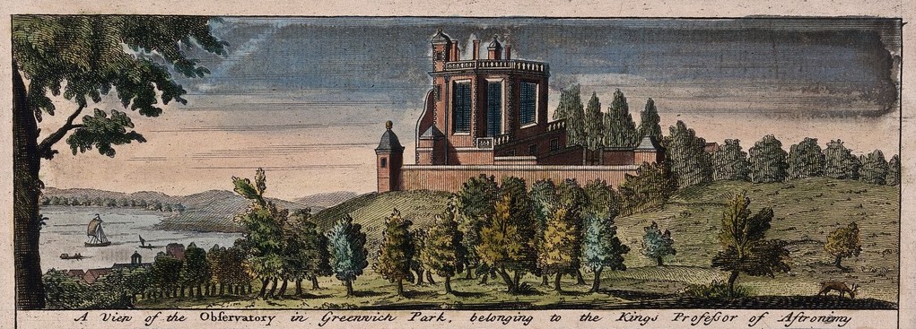
Figure 4: The Royal Observatory, Greenwich Hill, colored engraving, 1723, courtesy Wellcome Collection .
The tools developed in the eighteenth century – astronomical tables, sextants, timekeepers – remain essential equipment for ships today as back-up technologies. Alternative astronomical methods were developed and lunar-distance tables were omitted from almanacs in the first decade of the twentieth century. 35 This move was accelerated by the arrival of radio signals, and receivers on board ship, that could provide time signals against which to compare chronometers. The first wireless time signals used for maritime navigation were probably those broadcast by the US Navy in 1904, and the French Bureau des longitudes pressed for the signals that began to be broadcast from the Eiffel Tower in 1910. 36
Since the second half of the twentieth century, positioning systems have played an increasingly important role. While beacons, signals and lighthouses have long created local systems to aid shipping around dangerous coasts and into the safety of harbors, radio and satellite technology allowed the development of longer-range and global systems. As before, military funding has often been key to the implementation of these systems, such as LORAN, a hyperbolic radio navigation system developed by the US during the Second World War, and GPS, the radionavigation-satellite service commenced by the Department of Defense in 1973, although the Decca Navigator System was developed by a private British company. 37 GPS-enabled devices have made positioning ourselves on a map seemingly simple, though the measurements of longitude are ever-present in GPS coordinates. Nevertheless, the possibility such electronic systems could be compromised means that some navies have reintroduced training in astronomical navigation, which remains the only way to re-establish longitude if it has been lost.
Bibliography
Andrewes, W.J.H., ed. The Quest for Longitude: The Proceedings of the Longitude Symposium Harvard University, Cambridge, Massachusetts November 4-6, 1993 . Cambridge, MA: Harvard University, Collection of Historical Scientific Instruments, 1996. ( Link to IsisCB )
Barrett, Katy. “The Wanton Line: Hogarth and the Public Life of Longitude.” PhD thesis, University of Cambridge, 2014.
Bartky, Ian R. One Time Fits All: The Campaigns for Global Uniformity . Stanford, CA: Stanford University Press, 2007. ( Link to IsisCB )
Bennett, Jim. “Catadioptrics and Commerce in Eighteenth-Century London.” History of Science 44, no. 2 (2006): 247–78.
Betts, Jonathan. Marine Chronometers at Greenwich: A Catalogue of Marine Chronometers at the National Maritime Museum, Greenwich . Oxford: Oxford University Press, 2018. ( Link to IsisCB )
Blanchard, Walter. “The Genesis of the Decca Navigator System.” The Journal of Navigation 68, no. 2 (2015): 219–37.
Bret, Patrice. “Funding and Directing Research or Rewarding Scientific Achievements? Two Centuries of Prizes at the Academy of Sciences in Paris.” Nuncius 34, no. 2 (2019): 317–55. ( Link to IsisCB )
Davids, Karel. “Finding Longitude at Sea by Magnetic Declination on Dutch East-Indiamen, 1596-1795.” The American Neptune 50, no. 4 (1990): 281–90. ( Link to IsisCB )
Davidson, Simon C. “The Use of Chronometers to Determine Longitude on East India Company Voyages.” The Mariner’s Mirror , 102, no. 3 (2016): 344–48.
de Grijs, Richard. “European Longitude Prizes I. Longitude Determination in the Spanish Empire.” Journal of Astronomical History and Heritage 23, no. 3 (2020): 465–94.
de Grijs, Richard. “European Longitude Prizes II. Astronomy, Religion and Engineering Solutions in the Dutch Republic.” Preprint: 2020, http://128.84.4.27/pdf/2101.04760 .
Dunn, Richard and Rebekah Higgitt. Finding Longitude: How Clocks and Stars Helped Solve the Longitude Problem . Glasgow: Collins, 2014. ( Link to IsisCB )
Dunn, Richard, and Rebekah Higgitt, eds. Navigational Enterprises in Europe and its Empires, 1730 – 1850 . London: Palgrave Macmillan, 2016.
Fauque, Danielle M. E. “Testing Longitude Methods in Mid-Eighteenth Century France.” In Navigational Enterprises in Europe and its Empires, 1730 – 1850 , edited by Richard Dunn and Rebekah Higgitt, 159–79. London: Palgrave Macmillan, 2016.
Higgitt, Rebekah. “There Was No Such Thing as the Longitude Prize.” Royal Museums Greenwich blog, March 7, 2012. https://www.rmg.co.uk/discover/behind-the-scenes/blog/there-was-no-such-thing-longitude-prize .
Higgitt, Rebekah. “Equipping Expeditionary Astronomers: Nevil Maskelyne and the Development of ‘Precision Exploration’.” In Geography, Technology and Instruments of Exploration, edited by Fraser MacDonald and C.W.J. Withers, 15–36. Basingstoke: Ashgate, 2015.
Higgitt, Rebekah. “Challenging Tropes: Genius, Heroic Invention, and the Longitude Problem in the Museum.” Isis 108, no. 2 (2017): 371–80. ( Link to IsisCB )
Higgitt, Rebekah. “The Trinity House on Water Lane: Experience and Expertise.” In Rebekah Higgitt, Jasmine Kilburn-Toppin and Noah Moxham, Science Incorporated: London Sites and Cultures of Knowledge and Practice, 1600-1800 . Forthcoming.
Howse, Derek. Greenwich Time and the Longitude . London: Philip Wilson, 1997. ( Link to IsisCB )
Howse, Derek. “Britain’s Board of Longitude: The Finances, 1714-1828.” The Mariner’s Mirror 84, no. 4 (1998): 400–17. ( Link to IsisCB )
Jardine, Lisa. “Scientists, Sea Trials and International Espionage: Who Really Invented the Balance-Spring Watch?” Antiquarian Horology 9, no. 5 (2006): 663–83.
Jonkers, A.R.T. Earth’s Magnetism in the Age of Sail . Baltimore: Johns Hopkins University Press, 2003. ( Link to IsisCB )
Littlehales G. W. “The Decline of Lunar Distance for the Determination of the Time and Longitude at Sea.” Bulletin of the American Geographical Society 41, no. 2 (1909): 83–86.
May, W. E. “How the Chronometer Went to Sea.” Antiquarian Horology , 9, no. 6 (1976): 638–63. ( Link to IsisCB )
Mobbs, Tessa, and Robert Unwin. “The Longitude Act of 1714 and the Last Parliament of Queen Anne.” Parliamentary History , 35, no. 2 (2016): 152–70.
Miller, David Phillip. “Longitude Networks on Land and Sea: The East India Company and Longitude Measurement ‘in the Wild’, 1770–1840.” In Navigational Enterprises in Europe and its Empires, 1730 – 1850 , edited by Richard Dunn and Rebekah Higgitt, 223-47. London: Palgrave Macmillan, 2016.
Portuondo, Maria M. Secret Science: Spanish Cosmography and the New World . Chicago: University of Chicago Press, 2009. ( Link to IsisCB )
Randles, W. G. L. “Portuguese and Spanish Attempts to Measure Longitude in the 16th Century.” Vistas in Astronomy 81, no. 4 (1995): 235–41. ( Link to IsisCB )
Seidelmann, Kenneth P., and Catherine Y. Hohenkerk, eds. The History of Celestial Navigation: Rise of the Royal Observatory and Nautical Almanacs . Cham: Springer, 2020.
Selin, Helaine, ed. Encyclopaedia of the History of Science, Technology and Medicine in Non-Western Cultures . Dordrecht: Springer, 2008. ( Link to IsisCB )
Sobel, Dava. Longitude: The True Story of a Lone Genius Who Solved the Greatest Scientific Problem of His Time . New York: Walker & Company, 1995. ( Link to IsisCB )
Stewart, Larry. “The Longitudinarians.” In The Rise of Public Science: Rhetoric, Technology, and Natural Philosophy in Newtonian Britain, 1660-1750 , 183–211. Cambridge: Cambridge University Press, 1992.
Vanvarenbergh, Michel and Peter Ifland. Line of Position Navigation: Sumner and Saint-Hilaire, the Two Pillars of Modern Celestial Navigation. Bloomington, IN: Unlimited Publishing LLC, 2003.
Wess, Jane. “Navigation and Mathematics: A Match Made in the Heavens?” In Navigational Enterprises in Europe and its Empires, 1730 – 1850 , edited by Richard Dunn and Rebekah Higgitt, 201–22. London: Palgrave Macmillan, 2016.
Withers, Charles W. J. Zero Degrees: Geographies of the Prime Meridian . Cambridge, MA: Harvard University Press, 2017. ( Link to IsisCB )
Whiston, William. Preface to Longitude Discovered by the Eclipses, Occultations and Conjunctions of Jupiter’s Planets . London, 1738.
-
See chapters on navigation in Africa, China, India, the Indian Ocean, Pacific and Polynesia in Selin, Encyclopaedia . ↩
-
Stewart, “The Longitudinarians”; Barrett, “The Wanton Line.” ↩
-
Sobel, Longitude . ↩
-
Higgitt, “Challenging Tropes.” ↩
-
E.g., in the UK context, Howse, Greenwich Time ; Andrewes, The Quest ; Dunn and Higgitt, Finding Longitude . ↩
-
Howse, Greenwich Time , 18. ↩
-
Dunn and Higgitt, Finding Longitude , 25, 28; Portuondo, Secret Science , 223–56. ↩
-
Quoted in Randles, “Portuguese and Spanish,” 235. ↩
-
Randles, “Portuguese and Spanish,” 236. ↩
-
Jonkers, Earth’s Magnetism , 53-61; Davids, “Finding Longitude.” ↩
-
De Grijs, “European Longitude Prizes I.” ↩
-
De Grijs, “European Longitude Prizes II,” 1. ↩
-
Bret, “Funding and Directing,” 321. ↩
-
De Grijs, “European Longitude Prizes II,” 3–4. ↩
-
Higgitt, “The Trinity House.” ↩
-
De Grijs, “European Longitude Prizes II,” 3, 6. ↩
-
Howse, “Britain’s Board”; Higgitt, “There Was No Such Thing as the Longitude Prize.” ↩
-
Dunn and Higgitt, Finding Longitude , 45. ↩
-
11 June 1714, Journals of the House of Commons , vol. 17 (London, 1803), 677. ↩
-
11 June 1714, Journals of the House of Commons , vol. 17 (London, 1803), 677. ↩
-
Jardine, “Scientists, Sea trials”; Betts, Marine Chronometers , 120–23. ↩
-
Collectively, the papers of the Harvard Longitude Symposium in 1993, published in Andrewes, The Quest , put emphasis on horology over astronomical or other solutions. This event inspired Dava Sobel’s book, which overplays the role of John Harrison, as the ‘lone genius’ who solved the problem and the hostility of the Board of Longitude toward timekeeping solutions. ↩
-
Isaac Newton, Papers on Finding the Longitude at Sea, MS Add. 3972, f. 38, https://cudl.lib.cam.ac.uk/view/MS-ADD-03972/75 . ↩
-
Miller, “Longitude Networks.” ↩
-
The papers of the Board of Longitude are available at Cambridge Digital Library, including the minutes which have also been transcribed: https://cudl.lib.cam.ac.uk/collections/rgo14/1 . ↩
-
Dunn and Higgitt, Finding Longitude , 77–92, 95–96. Harrison’s timekeepers, now known as H1-H4 are at the National Maritime Museum (ZAA0034-0037). ↩
-
Fauque, “Testing Longitude Methods.” ↩
-
Bennett, “Catadioptrics and Commerce.” ↩
-
Dunn and Higgitt, Finding Longitude , 108, 137–144. ↩
-
Davidson, “The Use of Chronometers”; Wess, “Navigation and Mathematics”; Miller, “Longitude Networks”; chapters by Juan Pimentel, Karel Davids, Guy Boistel and Simon Werrett in Dunn and Higgitt, Navigational Enterprises look at events in the Spanish Empire, Netherlands, France and Russia. ↩
-
Wess, “Navigation and Mathematics”; May, “How the Chronometer.” ↩
-
Vanvarenbergh and Ifland, Line of Position . ↩
-
Seidelmann and Hohenkerk, The History of Celestial Navigation , 157–311. ↩
-
Withers, Zero Degrees ; Bartky, One Time Fits All . ↩
-
Littlehales, “The Decline of Lunar Distance.” ↩
-
Howse, Greenwich Time, 154–55. The minutes of the Bureau des longitudes have been digitized and are partially transcribed at http://bdl.ahp-numerique.fr/ . ↩
-
Blanchard, “The Genesis.” ↩